As an avid landscape photographer, I create tens of thousands of photos every year. Over a thousand of these are posted to my Flickr pages. Dozens more, plus advice and other useful information are on my website, Best-Landscape-Photography.com. It's from these locations that many people doing web searches find my work. Some merely admire it, some take it, and a few offer to buy it.
A few weeks ago, I got an e-mail from a guy creating a new website for people who love to explore Colorado as much as I do. His site, RokSlide.com, needed photos for many of the trails he was describing. I offered him as many of mine as he wanted in exchange for links. He agreed, and now he's using my images to enhance his description of at least ten hikes. I like the format of his site, and am eager to see how it evolves. I'll probably use it myself for areas with which I'm unfamiliar.
The Black Canyon of the Gunnison
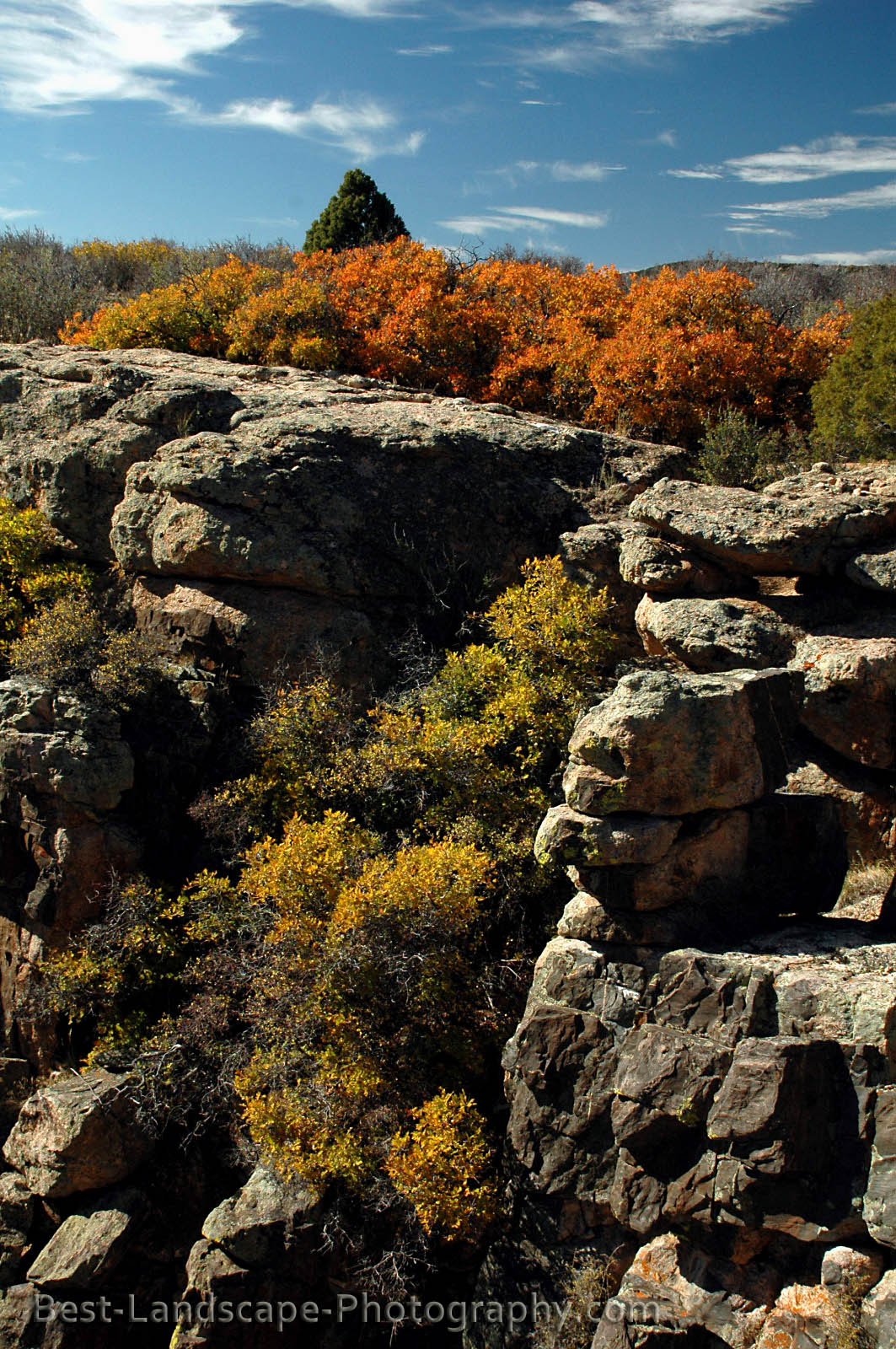


About an hour and a half south of my house is the Black Canyon of the Gunnison. Because it's so close, I try to get down there at least once a year. A few weeks ago, I realized I had yet to visit this year, so I made the journey on a gorgeous autumn afternoon.
It's a challenge to capture the canyon's impressive majesty with photographs. Because it's so narrow and deep, little light makes its way to the bottom. In October, the low angle of the sun allows even less light to penetrate the depths of the canyon. That does nothing to diminish the experience of viewing it from any of the overlooks on the north or south rims, and thus I don't hesitate to visit regardless of the time of year.
The scrub oak was still ablaze in color so late in the season, and the rim of the canyon has a lot of it, along with pinon pine, cacti, and other high desert flora.
The Cimarron Valley, near Owl Creek Pass


The Cimarron River valley in southwest Colorado is filled with groves of aspen trees and many imposing mountain peaks. I had driven through here after camping below Owl Creek Pass, and was struck the beauty of the area. Few others were around, even though it was only mid-autumn. Ever since then, I had wanted to return when the fall colors were at their peak. I did that this past weekend, and while the weather wasn't cooperating, I did manage to get a few good photographs.
The Crystal River Valley, South of Redstone, Colorado


A familiar trail I've avoided for a while was a perfect place for a short hike last Saturday afternoon. Few other places have sage brush, scrub oak, and aspen trees. Because colors are changing later this year, the scrub oak is peaking while the aspens are changing. It's a great time for landscape photography, especially when using a polarizing filter.
This unmarked trail goes by many names, and is on few maps. Driving north from Placita to Redstone, the road descends into a canyon. On the right is a turn-out, and on the left one can pick the grade of a long-abandoned road bed climbing the western slope of the valley. If you're coming from Redstone, it's about three and a half miles south of the coke ovens on highway 133.
Duley Park on the Avalanche Creek trail


About four and a half miles up the Avalanche Creek trail is Duley Park, an open expanse that looks like a great place to build your dream home. For day-hikers, this is a great spot to enjoy lunch and take photos. Backpackers could make camp in the pines near the creek. On the other side of the clearing the trail continues its gentle climb toward Avalanche Lake - the last mile and a half of which is rather steep. There's also a junction with a trail that goes over a pass into Lead King Basin.
I often hike Avalanche Creek early in the season because of its low elevation and southern exposure. September is a nice time too, as the golden fields compliment the blue skies and puffy white clouds. In a couple of weeks, the aspens that cover the northern slopes of the valley will be ablaze in color, and I may return to photograph them.
The Avalanche Creek trailhead is in the campground at the end of the USFS road that turns east from Highway 133 about ten miles south of Carbondale, Colorado.
Frying Pan Lakes in the Hunter-Frying Pan Wilderness Area


We've made a couple of day-hikes to Frying Pan Lakes, but this was my first time camping there. It was also my first time going on a solo backpack trip. Not sure why I've waited so long to try an overnight trip alone, but I had such a good time, that I'll do it again. Backpacking alone means carrying the stove, fuel, water filter, tent, etc. yourself. Nobody else with whom to share the load. So I looked to save weight where I could, and managed to get a fully-loaded pack at thirty-nine pounds (not including my camera).
My map shows a trail beyond the lakes, over the saddle to the west of Deer Mountain, where there's a couple more small lakes, but I wasn't able to follow it. About a half mile south of the upper lake, the trail became ambiguous, and eventually stopped at a seemingly impenetrable field of willows. I climbed a boulder field, hoping to find a way around (or through), but eventually returned to the upper lake to take more photos. Later in the day, a trio of hikers, who had started at a hairpin turn below Independence Pass, came over the saddle and down through the lakes. They reported that they just pushed through the willows. I guess I'll have to try that sometime.
To reach the trailhead for Frying Pan Lakes, drive east from Basalt about thirty-two miles to where the road makes a hairpin turn and begins climbing towards Hagerman Pass. On your right is an improved dirt road that leads to the trailheads for both this hike and Lily Pad Lake. The trailhead is at 10,000 feet, and the lakes are at 11,000 feet. The surrounding peaks and ridges are above 13,000 feet, making for a very dramatic - and photogenic - scene. Roughly halfway to the lakes, the trail crosses the river via a sturdy bridge. This is a great place to stop, drink some water, and take a few photos.
Thomas Lakes and Mt. Sopris


Halfway to the summit of Mt. Sopris, south of Carbondale, Colorado, are Thomas Lakes. Two large lakes and several smaller ponds sit on a shelf on the north slope of the mountain. Other than the one time I made an unsuccessful attempt at climbing to the summit, I usually hike to and around Thomas Lakes every year.
The trailhead can be reached from Prince Creek Road or West Sopris Creek Road. The trail is about four miles each way, with a vertical gain of 1,600 feet.
American Lake near Aspen


Not far from the popular Cathedral Lake hike in the Maroon Bells-Snowmass Wilderness Area south of Aspen is American Lake. Surrounded by steep cliffs that rise nearly two thousand feet above the lake, this hike is well worth the effort. The trail climbs about 1,700 feet over three and a half miles, and has very good footing most of the way. Once at the lake, it's not difficult to walk its circumference, and something I recommend, since there's nowhere else to go except back down.
The trailhead is a couple of miles shy of the ghost town of Ashcroft, on the south side of the Castle Creek valley.
The Savage-Carter Lakes loop in the Holy Cross Wilderness Area


Ever since we discovered that one can descend from Carter Lake via the "non-inventoried" trail, our annual trips to Savage Lake always include Carter Lake. Another common thread is the deterioration of the weather on those days we choose to do this hike, and thus I've not been very satisfied with the photos I get of the upper Savage Lake or Carter Lake. Still, the hike is always a pleasure, and this past weekend was no different.
Because of light rain, I left my camera in the pack at Savage Lakes, but did pull it out when we crossed the stream leading out of Carter Lake, and got these shots of Elephant Heads and a fisherman plying the waters (with great success).
The trailhead for this hike is in the Frying Pan river valley. Just east of Thomasville, past the road to Eagle, there's a dirt road on the left that leads to several USFS campgrounds and the trailheads of this hike and Josephine Lake.
The Yule Creek Valley in the Raggeds Wilderness
My home in the Crystal River valley is bordered to the northeast by the Snowmass-Maroon Bells Wilderness and to the southeast by the Raggeds Wilderness. There are many fantastic trails in this under-traveled area. My favorite is easily Yule Creek. From just below the top of the quarry road south of Marble, Colorado, the trail climbs about 1,500 feet in the first mile and a half. At this point, you're on an overlook above a beautiful hanging valley.


I call those three peaks "the Baby Bells," because of their resemblance to the Maroon Bells - the most photographed feature in the state. The taller one on the right is Mt. Justice. The wide area below is Thompson Flats.
If you descend to Thompson Flats, there's a stream crossing (which is running very high and fast this year). I recommend a pair of water shoes, as I try my best to keep my shoes and socks dry for my hiking comfort.
From here, the trail is relatively easy for the next mile or two as it winds through wildflower meadows and past rapids and small waterfalls. Eventually it climbs to Yule Pass. At this point, some hikers will do an about-face and traverse the slope to Yule Lakes, whose exit streams crossed the trail along the way up.
Colorado's Holy Cross Wilderness Area
Of the four wilderness areas close enough to my home for day hiking, the one to which we most frequently return is the Holy Cross Wilderness Area. Named for the Mount of the Holy Cross, and dominated by the Sawatch Range, the Holy Cross Wilderness Area is most easily accessed from the south via the Fryingpan River valley, and from the north via several roads leading out of the Eagle-Edwards-Avon corridor along I-70.
Some of our favorite hikes, including those we do annually, include:
Lyle and Mormon lakes
Savage Lakes (and the Savage-Carter loop)
Josephine Lake
Eagle Lake
Coming out of the Roaring Fork valley, these are the ones most accessible to us, but the area is rich with great trails, and contains some of the best scenery you'll find anywhere.
Josephine Lake in the Holy Cross Wilderness
To the west of Savage and Carter lakes in the Holy Cross Wilderness Area is Josephine Lake. It's a longer and more strenuous hike than the Savage-Carter loop, but one worth doing once you've done the others.


To reach the trailhead, take the North Fork Road (#501), a left turn from the Frying Pan road, a little ways east of Thomasville. It's the same road you take to reach the Savage Lakes trailhead, but you don't need to go nearly as far. Keep a lookout for the signs indicating the trailhead on your left.


To reach the trailhead, take the North Fork Road (#501), a left turn from the Frying Pan road, a little ways east of Thomasville. It's the same road you take to reach the Savage Lakes trailhead, but you don't need to go nearly as far. Keep a lookout for the signs indicating the trailhead on your left.
Beckwith Pass
 |
| Beckwith Mountain as seen from a meadow above Beckwith Pass |
A pleasant hike near Kebler Pass is Beckwith Pass. The trail passes through aspen groves and meadows of wildflowers, topping out with great views from the pass. To the east is Beckwith Mountain (east and west), where the sharp eye can pick out waterfalls.
Though the trailhead is east of the Lost Lake Slough, it's possible to reach this trail from the Three Lakes trail too. Take the road over Kebler Pass, west from Crested Butte or east from the Paonia Dam.
Avalanche Creek 2011
Thank goodness the trail stays north of the water, as it's running very high and fast this year.
Plenty of wildflowers abound, especially shooting stars.


Plenty of wildflowers abound, especially shooting stars.


The trailhead is at the end of the Avalanche Creek Road, on the east side of the USFS campground. The road joins Highway 133 about ten miles south of Carbondale.
Avalanche Creek, in the Crystal River valley

I'm thinking I should hike up Avalanche Creek this week. It's a great early-season hike because of its low elevation and good exposure to the sun.
The trailhead is about ten miles south of Carbondale, Colorado, and provides great access to the west side of the Snowmass-Maroon Bells wilderness area. Hikers will find many wildflowers in the meadows and clearings.
The Glenwood Springs Whitewater Park
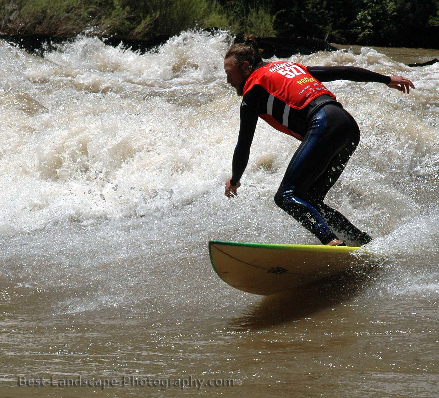


In between wilderness adventures, consider a raft trip down the Colorado River. If you're an experienced kayaker or surfer, you might enjoy the waves at Glenwood's whitewater park.
The shots above were taken during a competition when the river was running well over 20,000 cubic feet per second - more than double the seasonal average.
The whitewater park is below the Midland Avenue bridge, next to the west Glenwood exit on I-70.
Horsethief Canyon SWA, Grand Junction, Colorado
Northwest of Grand Junction is the Horsethief Canyon State Wildlife Area. A half-dozen or so trailheads access many canyons to the north of the Colorado National Monument.
This area is high desert, and travelers unaccustomed to this environment should bring plenty of water and pay attention to their route so they can find their way back.
 |
| Devil's Canyon |
This area is high desert, and travelers unaccustomed to this environment should bring plenty of water and pay attention to their route so they can find their way back.
Marble, Colorado
Marble, Colorado is an unsightly little town nestled in one of the most beautiful valleys you'll ever see. Sandwiched between the Raggeds and Snowmass-Maroon Bells wilderness areas, and with Lead King Basin to the east, Marble is a great jumping-off point for many backcountry trips.


Backpacking and day-hikes, horseback trips, and fishing are just a few of the many things you can do in the Crystal River valley around Marble.
Some of my favorite hikes in the area are Carbonate Creek, North Lost Creek, Geneva Lake, and Yule Creek. Backpackers will want to hike into Lead King Basin, where there are many campsites, and the scenery is unparalleled.
The Chair Mountain Ranch has cabins you can rent for any length of time. Dave and Linda are great hosts, and will do all they can to ensure you have a great stay.
Marble is about twenty five miles south of Carbondale. Take Highway 133 south to Gunnison County Road 3 (affectionately known as "the Marble road").
 |
| The Marble airstrip is quiet for all but a couple weekends a year. |


Backpacking and day-hikes, horseback trips, and fishing are just a few of the many things you can do in the Crystal River valley around Marble.
Some of my favorite hikes in the area are Carbonate Creek, North Lost Creek, Geneva Lake, and Yule Creek. Backpackers will want to hike into Lead King Basin, where there are many campsites, and the scenery is unparalleled.
The Chair Mountain Ranch has cabins you can rent for any length of time. Dave and Linda are great hosts, and will do all they can to ensure you have a great stay.
Marble is about twenty five miles south of Carbondale. Take Highway 133 south to Gunnison County Road 3 (affectionately known as "the Marble road").
Carbondale, Colorado
 |
| Enjoying the view from Mushroom Rock |


Named by national magazines as a great sports town, Carbondale, Colorado is a fantastic little town nestled in the Rocky Mountains. It's a half hour from Aspen, and within a short drive to several wilderness areas (Snowmass-Maroon Bells, Raggeds, Holy Cross, Flattops, Hunter-Frying Pan). Many miles of bike paths; rivers that are great for fishing, kayaking, and rafting; plenty of horseback riding opportunities; nearby trails for hiking and mountain biking; and great restaurants, art galleries, and entertainment venues all make Carbondale a favorite for locals and visitors.
Carbondale is about a dozen miles south of I-70 on Highway 82. Use the east exit in Glenwood Springs. It's also about a half hour from Aspen, if you're inclined to visit there.
Lost Lake Slough and the Three Lakes Trail loop

Not far from Kebler Pass, at the base of the Beckwith Mountains, is Lost Lake Slough. In addition to being a great car-camping area, it's the trailhead for the Three Lakes trail loop. The loop is relatively easy and takes you past a great waterfall in addition to the lakes.
To reach Lost Lake Slough, take the Kebler Pass road west out of Crested Butte or east from the Paonia Reservoir.
The Ruby Anthracite Trail near Kebler Pass

A few miles west of Kebler Pass is the Ruby Anthracite trail. Unlike most trails in the mountains, this one descends from the trailhead. If you continue past the beaver ponds beneath Marcellina Mountain (pictured above), you'll drop into Dark Canyon via the Devil's Staircase. If you have two vehicles, or don't mind hitch-hiking, you can hike all the way to Ericson Springs (or to Marble via Anthracite Pass).
Cathedral Lake near Aspen
The Castle Creek valley, south of Aspen, Colorado is host to several great trails. One I'm eager to do again is Cathedral Lake.

The trail is moderately steep and rocky, but not difficult, and hikers are rewarded with great views on the way up and a spectacular scene at the top. The above shot was taken in late summer, when the water levels were lower. I'm eager to do this hike earlier in the season, along with its neighbor, American Lake.
The trailhead for Cathedral Lake is not too far past the ghost town of Ashcroft, on the right hand (south) side of the road.
Hanging Lake - the stills
See the videos and read my description of the hike here.


If you want to see Hanging Lake in winter, check out this entry.
Hanging Lake has its own exit from eastbound I-70 in Glenwood Canyon. Westbound travelers need to overshoot it and turn around at Grizzly Creek.
Hanging Lake - the videos
Hanging Lake is one of the most popular hikes in Colorado. It's relatively short, about a mile and a quarter, easily accessed off I-70, close to Glenwood Springs, and very scenic.
I've hiked up there a half dozen or so times, including once in the middle of winter. Yesterday's trip up was much fun as the spring melt-off is fueling the state's rivers and streams, and there are torrents of water everywhere.
At points the trail had more water than the stream normally does. The crossing to the Dead Horse trail was out of the question. Spouting Rock, above the lake, could have been called Gushing Rock.
Here are a few videos I shot:
Seasonal streams and falls will run high and fast this year


Hikers and backpackers in the Colorado mountains should expect more snow and tricky stream crossings this year. Near-record snowpack at the upper elevations is going to take longer to melt and will add much more water to the run-off that feeds seasonal streams and waterfalls like the one pictured above.
This seasonal waterfall begins flowing in March and dries up in June each year. At its peak in May, it's really gushing as it flows into the Crystal River south of Redstone, Colorado.
Subscribe to:
Comments (Atom)
