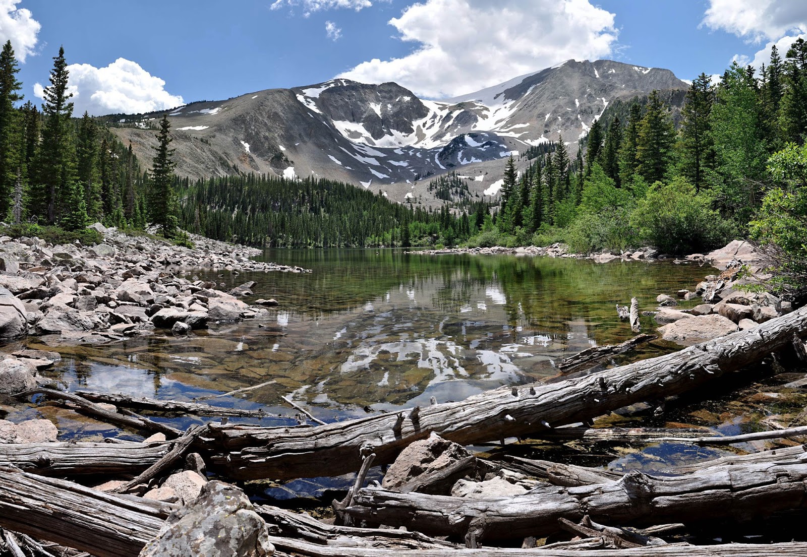
Welcome to the Colorado backcountry

The vast acreage of wilderness and backcountry beauty in Colorado make it one of the more popular locations for camping, backpacking, and day-hiking.

In addition to a eight National Parks and Monuments, Colorado boasts an equal number of Wilderness Areas, millions of acres of National Forest and BLM land, and over three dozen state parks.

From mountains to deserts, and grasslands to canyons, one could spend a lifetime hiking the trails of Colorado and not cover all of them.
Showing posts with label hiking. Show all posts

The Crested Butte to Aspen Traverse

One popular hike (I hate popular hikes, and prefer to seek solitude in the backcountry, but my buddy loves things that are popular) is the traverse between Crested Butte and Aspen (or vice versa).  It actually goes from Schofield Pass to Maroon Lake, and much of it is part of the popular (there's that word again) Four Pass Loop.

The scenery and views are one major reason this hike is favored by so many.

crested butte, aspen, traverse, maroon pass, maroon bells
Looking northwest from West Maroon Pass

maroon, pass, maroon bells, aspen, crested butte
Looking east from West Maroon Pass

Scarp Ridge

Though I moved from Colorado a couple of years ago, I return there every summer to visit friends and explore the wilderness.  Last month I did some hikes in the Crested Butte area that were all new to me, even though I lived not from from there (with only the Raggeds Wilderness separating us).

On my first day back, my buddy chose as an acclimation hike the trail from Lake Irwin to Scarp Ridge and a "peak" (it shows up on few maps, so maybe it's more of a point than a peak) called Oh Be Joyful at 12,400 feet above sea level.

From this point, hikers are rewarded with 360-degree views, which were partially marred by smoke from the west's many wildfires when we were there.  Still, I got some photos worth sharing:

scarp ridge, crested butte, colorado, hiking, wilderness, panorama
looking east from Scarp Ridge

hiking, colorado, crested butte, wilderness, oh be joyful
looking north from Oh Be Joyful

Huntsmans Ridge

What was my go-to hike last summer has not seen my feet until today.  The rain we've enjoyed encouraged many wildflowers and mushrooms, along with some biting flies (a rarity out here).

I took the ridge out to the overlook to capture some panoramas and HDRs.  You'll want to click on the panos to see them best.

click on image to see large

colorado, mountains, hiking

click on image to see large

colorado, hiking

Yule Creek

No matter how many photos I share of this place, it never gets spoiled.  Even last week, when there were a half dozen cars at the trailhead, we saw only one person on the trail (the trailhead serves two trails, and many take the less scenic one, for reasons that elude me).

a big ass panorama that you have to click to appreciate

colorado, wilderness, raggeds, marble

old steam engine on the trail

May rains mean amazing June flowers

.....and deep lakes.

Our hike to Thomas Lakes was fantastic because of the wealth of wildflowers on the trail.  Then we reached the eastern lake and found it holding more water than I had ever seen.  Just a couple of years ago, it was about five feet lower.

colorado, mountain, lake, hiking

colorado, mountain, wilderness, wildflowers

This was the first time I remember seeing all-white columbines.

High Water in the High Country

The heavy precipitation in May recharged the snowpack and has the streams, creeks, and rivers running very high.

This past weekend's trip up Avalanche Creek -- normally just an early season hike, but one we opted to do after encountering much snow on an attempt to reach Savage Lakes -- showed us just how much water was rushing downhill now.  Both Hell Roaring and Avalanche Creeks were flowing at rates I've never seen before.

colorado wilderness creek hiking
Hell Roaring Creek

colorado backcountry wilderness hiking creeks

colorado creek wilderness
Avalanche Creek

American Lake, near Aspen, Colorado

American Lake is in the Castle Creek valley, southwest of Aspen, Colorado.  It's in the Snowmass-Maroon Bells Wilderness Area.  Like nearby Cathedral Lake, it's a popular hike for both the scenery and proximity to the famous ski town. 

I had hiked there once before, but the skies were cloudy, and I wasn't terribly pleased with my photos.  We had perfect weather for the hike and for photography yesterday, and here's what I brought back.

the upper half of the trail passes through pine groves

the gray jays, known as camp-robbers, are used to seeking food from hikers

american lake, aspen, colorado, hike, trail
visitors are struck by the beautiful color of the lake

american lake, aspen, colorado, hike, trail

american lake, aspen, colorado, hike, trail

Grizzly Creek -- another great early season hike

Grizzly Creek, glenwood canyon, glenwood springs, colorado
grizzly creek cascades

bouldering opportunities along the trail

Grizzly Creek, glenwood canyon, glenwood springs, colorado
black and white riverscape

Early season in Colorado, otherwise known as mud season, is characterized by snow-clogged trails, muddy trails, and fast-moving water crossings.  Or you can seek out low elevation hikes with good sun exposure.  I've written about how Avalanche Creek is one of those.  Several more can be found in Glenwood Canyon. 

No Name Creek, Grizzly Creek, and Hanging Lake/Dead Horse Creek are some of the trails that lead north from the Colorado River into the Flat Tops wilderness.

A new resource for Colorado trail information

As an avid landscape photographer, I create tens of thousands of photos every year.  Over a thousand of these are posted to my Flickr pages.  Dozens more, plus advice and other useful information are on my website, Best-Landscape-Photography.com.  It's from these locations that many people doing web searches find my work.  Some merely admire it, some take it, and a few offer to buy it. 

A few weeks ago, I got an e-mail from a guy creating a new website for people who love to explore Colorado as much as I do.  His site, RokSlide.com, needed photos for many of the trails he was describing.  I offered him as many of mine as he wanted in exchange for links.  He agreed, and now he's using my images to enhance his description of at least ten hikes.  I like the format of his site, and am eager to see how it evolves.  I'll probably use it myself for areas with which I'm unfamiliar.

Avalanche Creek, in the Crystal River valley


I'm thinking I should hike up Avalanche Creek this week.  It's a great early-season hike because of its low elevation and good exposure to the sun.

The trailhead is about ten miles south of Carbondale, Colorado, and provides great access to the west side of the Snowmass-Maroon Bells wilderness area.  Hikers will find many wildflowers in the meadows and clearings.

Marble, Colorado

Marble, Colorado is an unsightly little town nestled in one of the most beautiful valleys you'll ever see.  Sandwiched between the Raggeds and Snowmass-Maroon Bells wilderness areas, and with Lead King Basin to the east, Marble is a great jumping-off point for many backcountry trips.

The Marble airstrip is quiet for all but a couple weekends a year.


Backpacking and day-hikes, horseback trips, and fishing are just a few of the many things you can do in the Crystal River valley around Marble.

Some of my favorite hikes in the area are Carbonate Creek, North Lost Creek, Geneva Lake, and Yule Creek.  Backpackers will want to hike into Lead King Basin, where there are many campsites, and the scenery is unparalleled.

The Chair Mountain Ranch has cabins you can rent for any length of time.  Dave and Linda are great hosts, and will do all they can to ensure you have a great stay.

Marble is about twenty five miles south of Carbondale.  Take Highway 133 south to Gunnison County Road 3 (affectionately known as "the Marble road").

Carbondale, Colorado

Enjoying the view from Mushroom Rock


Named by national magazines as a great sports town, Carbondale, Colorado is a fantastic little town nestled in the Rocky Mountains.  It's a half hour from Aspen, and within a short drive to several wilderness areas (Snowmass-Maroon Bells, Raggeds, Holy Cross, Flattops, Hunter-Frying Pan).  Many miles of bike paths; rivers that are great for fishing, kayaking, and rafting; plenty of horseback riding opportunities; nearby trails for hiking and mountain biking; and great restaurants, art galleries, and entertainment venues all make Carbondale a favorite for locals and visitors.

Carbondale is about a dozen miles south of I-70 on Highway 82.  Use the east exit in Glenwood Springs.  It's also about a half hour from Aspen, if you're inclined to visit there.

The Ruby Anthracite Trail near Kebler Pass


A few miles west of Kebler Pass is the Ruby Anthracite trail.  Unlike most trails in the mountains, this one descends from the trailhead.  If you continue past the beaver ponds beneath Marcellina Mountain (pictured above), you'll drop into Dark Canyon via the Devil's Staircase.  If you have two vehicles, or don't mind hitch-hiking, you can hike all the way to Ericson Springs (or to Marble via Anthracite Pass).

Maps - find a trail, and find your way along one with good maps

Over twenty years ago, I was camping in Rocky Mountain National Park when a woman straggled out of the woods looking both lost and relieved that she wasn't in the woods anymore.  In her hand was an 8.5" x 11" sheet of paper that could only be described as a photocopy of a hand-drawn trail map.  She was many miles from where she wanted to be, and ill-equipped to get there.

Years before, I learned the value of a good map when introduced to the topographical maps produced by the U.S. Geologic Survey (USGS).  I never went on a backpack or day-hike trip without one.  The scale, accuracy, and level of detail on these maps made them indispensable to the outdoor explorer.

Today, I favor maps from Trails Illustrated, part of National Geographic.  They begin with USGS topo maps, and review them for accuracy and changes, then print them on waterproof paper.  Each map contains several USGS maps, so the scale is manageable, and the area covered is broad enough that one map should have enough coverage for a multi-day loop. 

To find new areas to explore, or find my way to a trailhead, a road atlas won't do.  The Colorado Atlas & Gazetteer from DeLorme is in my car all the time (unless I bring it inside to examine).  The DeLorme Atlas & Gazetteer series now covers all fifty states (they used to make them for only the states worth visiting).  They also offer GPS downloads, digital maps, and other useful things to help you find your way in the backcountry.

Being somewhat "old school," I prefer maps and a compass to a GPS receiver.  The latter can be heavy, requires batteries, and tells you where you are - not which direction you're facing.

Avalanche Creek - great early season hike


Once skiing is done, we in Colorado refer the next few weeks as "mud season."  Like the name implies, the retreating snows leave behind a lot of muddy trails.  One of my favorite early season hikes is Avalanche Creek.  It works well for a few reasons.  The first is its elevation.  The trailhead starts at 7,400 feet, which isn't too high.  By mid-April, that area is usually snow-free.  The east-west orientation of the valley also works toward its favor, as it gets sun all day long by then, and dried out quickly.

Because of the seasonal closure of the Avalanche Creek road (to protect the bighorn sheep), you might need to park at the gate and walk a couple miles to the trailhead.  The walk itself is pleasant enough.  Crossing Bulldog Creek is easy, and the first mile of the trail past the campground ought to be dry. 

In May, when higher elevation and northern-facing trails are still holding much snow, you can hike all the way past Duley Park (but not too much farther).

Snowshoeing up Huntsmans Ridge


After crossing this clearing, I heard some voices behind me, and descended a few yards so I could capture this photo.  Despite temperatures just below freezing, the sun and hard work of climbing a thousand feet through deep snow warm you up quickly, making a t-shirt the only thing you need to wear.  When I return to the ridge today, I'm bringing a dry shirt to put on when I get to the top.

I broke several miles of trail yesterday, and see no reason not to take advantage of that by following in my own footsteps today.  I'll probably seek out some fresh snow for part of my descent, as running down a snow-covered mountainside in snowshoes is almost as much fun as skiing down it (and much easier when the snow is thick and heavy).

Fresh Tracks


The wilderness areas that we hike in all summer are too snow-bound for day hikes in the winter.  Many trailheads are inaccessible, the trails themselves are in avalanche-prone areas, and we just can't go as far on snowshoes in deep snow as we can in hiking boots on dirt trails. 

So we stay closer to home, and explore the local areas that are easy to overlook in the summer.  Today we we went up Basalt Mountain Road, on Missouri Heights.  Cross-country skiers, many with dogs, were drawn to this route.  Most of the snow was trampled, but I found a few clean patches, including this one with the tracks of a mouse that had run across it.

Your day pack contents - what to carry on every hike in the mountains


It may sound like a cliche, but the weather in the mountains is very unpredictable.  It can snow any month of the year, and afternoon thunderstorms are very common in the summer.  Being prepared, by bringing the right things in your pack, can make the difference between a pleasant backcountry outing and a very uncomfortable - or dangerous - day in the wilderness.

  • A day pack should be large enough to hold your things, and have a hip-belt for both support and stability.  Pockets and loops for strapping on additional items are helpful.
  • Water - I bring two liters for every hike, and a water filter for long days.  It's easy to get dehydrated in the upper elevations, especially on strenuous hikes.
  • Sunscreen, lip balm, sunglasses, and sun hat - the high altitude sun is laser-like, and can scorch your skin in little time
  • Rain jacket and rain pants - the waterproof and breathable materials are well worth the extra cost; they're much more comfortable and keep you drier because they allow your body's moisture to evaporate
  • Fleece jacket and pants - there have been days in June and August when I was glad to have the added warmth of a fleece layer under my rain gear; if you have room, throw in a fleece hat and gloves
  • First aid kit, LED flashlight, butane lighter, pocketknife, and some nylon cord - you probably won't use them, but they take up little space, and you'll be damn glad you have them should the need arise
  • Food - you know what your body needs, so adjust accordingly; I tend to favor fruit (dried and fresh), nuts, cheese, and crackers, because they pack a lot of calories in a small amount of space and are very satisfying
  • A good topographic map - so many of the trails are easy to follow, and as you gain experience you'll be more confident in your ability to find your way around, but maps are helpful in identifying surrounding landmarks and knowing your elevation
  • Camera - whether it's a lightweight point-and-shoot or a fancy DSLR, you'll want to capture the scenery to share with friends and family
  • OPTIONAL (items that aren't necessary, but make things more comfortable if you're willing to carry them) - toilet paper, camp chair, light tarp (with grommets), camera tripod, spare socks
  • CLOTHING - the new wickable fabrics make life outside so much more comfortable, as they pull moisture away from the skin, keeping you dry and warm; whether you wear boots or sturdy shoes is your choice, but respect your feet in your choice of both footwear and socks - your feet are your way back to the trailhead

Winter Landcape


A hike up Avalanche Creek on a cold wintry morning yielded this photo of steam rising from the rapidly freezing water. Avalanche Creek is in the Crystal River valley, south of Carbondale, Colorado.

See more photos from the day, as well as photography from other outings, at:
www.flickr.com/photos/silbecl

autumn leaves

I really wanted to see how this red leaf would look on a black background. This is a scrub oak plant backlit by the afternoon sun. All the leaves and grasses really show off their fall colors when the sun is behind them.